Property Record
7108 Williams Rd, Flowery Branch, GA 30542


Property Detail
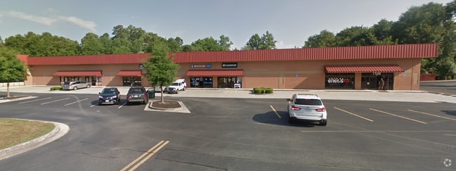
7108 Williams Rd
15-00042-00-016C
WILLIAMS ROAD
University
Hall
H-B
Georgia
B and X Area of moderate flood hazard, usually the area between the limits of the 100-year and 500-year floods.
3.03 AC
2025
Gainesville/Hall Cnty
2025
Atlanta
001605
Gainesville, GA
16,250 SF
NEARBY LISTINGS FOR SALE OR LEASE
-
-
View all Flowery Branch listings for sale on LoopNet.com
DEMOGRAPHICS near 7108 Williams Rd
1 mile
3 mile
5 mile
2025 Total Population
3,755
33,595
96,763
2030 Population
4,037
36,222
104,251
Pop Growth 2025-2030
+ 7.51%
+ 7.82%
+ 7.74%
Average Age
40
41
40
2025 Total Households
1,221
11,466
31,725
HH Growth 2025-2030
+ 7.53%
+ 7.97%
+ 7.93%
Median Household Inc
$127,500
$119,698
$110,764
Avg Household Size
3.00
2.90
3.00
2025 Avg HH Vehicles
2.00
2.00
2.00
Median Home Value
$462,962
$452,759
$442,285
Median Year Built
2004
2006
2004
Nearby Places
Map Layers
Map Styles
 Street
 Aerial
Layers
 Traffic
 Biking
Places
Listings with unknown addresses are not visible on the map
- Restaurants
- Banks
- Shops
- Fitness
- Groceries
Nearby Properties
Address
Land Use
TOTAL SIZE
Lot Size
Zoning
Address
Land Use
TOTAL SIZE
Lot Size
Zoning
105,000 SF
104.18 AC
POD
Address
Land Use
TOTAL SIZE
Lot Size
Zoning
372,813 SF
172.70 AC
RA200
Address
Land Use
TOTAL SIZE
Lot Size
Zoning
273,101 SF
126.33 AC
PRD
Address
Land Use
TOTAL SIZE
Lot Size
Zoning
30,720 SF
12.28 AC
G-C
Address
Land Use
TOTAL SIZE
Lot Size
Zoning
263,400 SF
8.65 AC
PRD
Address
Land Use
TOTAL SIZE
Lot Size
Zoning
114,835 SF
15.29 AC
POD
Address
Land Use
TOTAL SIZE
Lot Size
Zoning
46,400 SF
3.51 AC
G-C
Address
Land Use
TOTAL SIZE
Lot Size
Zoning
44,824 SF
3.22 AC
G-C
Address
Land Use
TOTAL SIZE
Lot Size
Zoning
24,486 SF
3.85 AC
G-C
Address
Land Use
TOTAL SIZE
Lot Size
Zoning
82,604 SF
13.11 AC
G-C
Address
Land Use
TOTAL SIZE
Lot Size
Zoning
31,094 SF
126.02 AC
RA200
Address
Land Use
TOTAL SIZE
Lot Size
Zoning
71,951 SF
8.78 AC
PRD
Address
Land Use
TOTAL SIZE
Lot Size
Zoning
1,280 SF
24.21 AC
PCD
Address
Land Use
TOTAL SIZE
Lot Size
Zoning
50,456 SF
58.60 AC
INST
Address
Land Use
TOTAL SIZE
Lot Size
Zoning
42,848 SF
4.55 AC
G-C
Address
Land Use
TOTAL SIZE
Lot Size
Zoning
15,000 SF
7.53 AC
G-C
Address
Land Use
TOTAL SIZE
Lot Size
Zoning
35,318 SF
6.72 AC
G-C
Address
Land Use
TOTAL SIZE
Lot Size
Zoning
94,098 SF
1.83 AC
MUNI
Address
Land Use
TOTAL SIZE
Lot Size
Zoning
17,900 SF
21.18 AC
RA200
Address
Land Use
TOTAL SIZE
Lot Size
Zoning
8,204 SF
5.25 AC
G-C
Address
Land Use
TOTAL SIZE
Lot Size
Zoning
191.82 AC
PUD
Address
Land Use
TOTAL SIZE
Lot Size
Zoning
1,412 SF
43 AC
OI
Address
Land Use
TOTAL SIZE
Lot Size
Zoning
93,158 SF
2.04 AC
PRD
Address
Land Use
TOTAL SIZE
Lot Size
Zoning
29,212 SF
2.64 AC
N-C
Address
Land Use
TOTAL SIZE
Lot Size
Zoning
17,110 SF
5.73 AC
PCD
Address
Land Use
TOTAL SIZE
Lot Size
Zoning
41,498 SF
4.56 AC
MUNI
Address
Land Use
TOTAL SIZE
Lot Size
Zoning
50,563 SF
24.35 AC
AR-1
Address
Land Use
TOTAL SIZE
Lot Size
Zoning
19,357 SF
10 AC
RA200
Address
Land Use
TOTAL SIZE
Lot Size
Zoning
22.22 AC
OI
Address
Land Use
TOTAL SIZE
Lot Size
Zoning
7.60 AC
AR-1
The World's #1 Commercial Real Estate Marketplace
Connect with us
© 2026 CoStar Group
The information above has been obtained from sources believed reliable. While we do not doubt its accuracy we have not verified it and make no guarantee, warranty or representation about it. It is your responsibility to independently confirm its accuracy and completeness. Any projections, opinions, assumptions, or estimates used are for example only and do not represent the current or future performance of the property. The value of this transaction to you depends on tax and other factors which should be evaluated by your tax, financial, and legal advisors. You and your advisors should conduct a careful, independent investigation of the property to determine to your satisfaction the suitability of the property for your needs.